Big news just hit the Phoenix building scene: EPCOR has received approval for an Alternative Designation of Assured Water Supply (ADAWS). This means builders in cities like Buckeye and Surprise finally have the green light to restart projects that were stopped because of water restrictions. For anyone working in real estate or development, this change means one thing—a big increase in requests for the ALTA Title Survey. When large construction projects start up again, every deal, loan, and land purchase needs a current survey to make sure everything is accurate and approved.
A Water Decision That Unlocks Thousands of New Homes
For more than a year, many builders in the West Valley couldn’t move forward. Arizona’s groundwater rules made it hard to get new subdivisions approved. Many projects sat unfinished, waiting for a solution.
Now, EPCOR’s ADAWS approval gives that solution. Instead of relying on limited groundwater, EPCOR can now guarantee a steady water supply for new communities. Local news like AZCentral and KJZZ reported that around 60,000 new homes could soon move forward.
This one policy change affects far more than builders. Engineers, surveyors, and title companies all need to take action before the first shovel hits the ground. And the first step for everyone is the ALTA Title Survey.
Why ALTA Title Surveys Come First
An ALTA Title Survey is a detailed map that shows exactly what exists on a property—boundaries, buildings, roads, and easements. Lenders and title companies require it to make sure what’s written in the property documents matches what’s really there.
When construction restarts after a long delay, the first step isn’t digging—it’s checking the land. A survey helps confirm:
- Property lines are correct and match county records.
- Easements are properly marked for utilities and drainage.
- Encroachments or boundary issues are identified early.
Without it, lenders can’t fund the project, and builders can’t close deals. That’s why the ADAWS decision is expected to create a rush of ALTA Title Survey requests. Every new plat, subdivision, or development must begin with a verified survey.
The Ripple Effect on Builders and Surveyors

The ADAWS approval is more than a water policy—it’s a construction restart button. Builders who’ve been waiting months are now rushing to move forward. That creates a chain reaction across Arizona’s surveying industry.
Survey firms around Phoenix expect 2–6 week wait times as requests pour in for both new and updated surveys. Projects that had old surveys may need them redone since property layouts, roads, or easements could have changed during the pause.
Developers are already working with title officers and surveyors to refresh their site information. Along with ALTA surveys, there’s also a growing demand for construction staking, topographic mapping, and flood zone updates as projects pick up speed.
How Builders Can Stay Ahead
When demand spikes, the biggest challenge isn’t funding—it’s timing. Many surveyors already have busy schedules, and those who plan early will avoid long delays.
Here’s how builders can stay ahead of the curve:
- Order your ALTA Title Survey early. Waiting too long could push your project back several weeks.
- Bundle services. Combine your ALTA, topographic, and staking surveys to save time and reduce repeat visits.
- Keep your team connected. Make sure your title, engineering, and construction teams are all using the same data.
Being proactive now helps builders start faster later. The sooner the survey is ordered, the sooner the permits and financing can move forward.
Why It Matters for Developers, Lenders, and Title Companies
The ADAWS approval doesn’t just help builders—it affects everyone involved in land development.
Developers need ALTA Title Surveys to confirm that their land meets legal and title requirements before planning or design. Lenders use surveys to check property boundaries, access, and encumbrances before they approve large loans. Title companies rely on updated survey data to match their records with the real-world conditions of the property.
When all three—developers, lenders, and title officers—have the same verified map, it reduces risk and prevents misunderstandings. The survey becomes the single trusted document that keeps every part of a real estate deal moving smoothly.
What’s Next for the Phoenix Market
Phoenix’s West Valley is once again gearing up for major growth. Buckeye and Surprise are expected to lead Arizona’s next big housing expansion. The ADAWS approval removes the biggest barrier that was slowing progress.
For surveyors, that means more opportunities—but also more pressure. Many will expand their crews or use drone technology to handle the flood of new requests. For developers, it means acting fast before the queue fills up.
This situation also shows how public policy drives private development. A single water decision has reignited an entire sector—from surveyors and engineers to homebuilders and investors.
From Policy to Progress
The story of EPCOR’s ADAWS approval is really about how one government decision can kickstart real progress.
When the water supply was uncertain, developers paused. When approval came through, confidence returned—and the phones at survey firms started ringing.
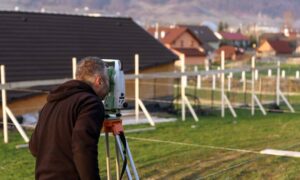
Now, across Buckeye and Surprise, you’ll see crews setting up tripods, flying drones, and marking corners again. Behind each of those jobs is an ALTA Title Survey—the quiet but essential document guiding the next wave of Arizona growth.
Final Thought
The new ADAWS approval turned uncertainty into opportunity. For Phoenix-area builders, it’s a sign to move quickly and plan smart.
Order your ALTA Title Survey early, work closely with your surveyor, and get ahead of the demand. The next chapter of Arizona’s development doesn’t start with construction—it starts with a clear and accurate survey map.


